
Infocus – Why DJI Terra is a Top Drone Mapping Software
All-in-one drone mapping and modeling solution.
If simplicity is the ultimate sophistication, DJI Terra stands out remarkably as an all-in-one drone mapping and modeling solution in a category where efficiency and precision are paramount to success
With now 400% more efficiency in data processing thanks to the latest update, planning, processing, analyzing and making more informed decisions with DJI Terra has never been easier.
Launched in 2019, DJI Terra was a response to a need for more streamlined solutions that could facilitate decision-making in critical sectors such as public safety, construction, infrastructure, or agriculture.
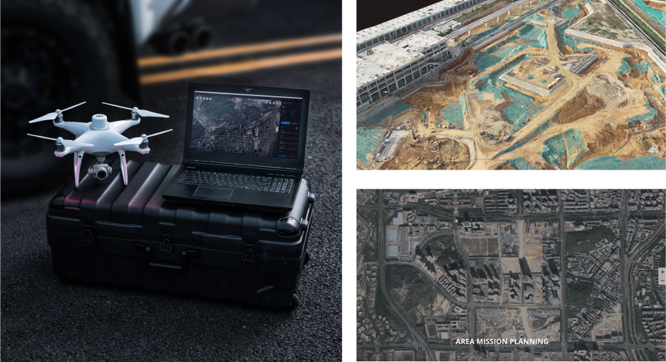
Today compatible with Phantom 4 RTK. P4 Pro, P4 Multispectral, Matrice 300 RTK + Zenmuse P1 and Zenmuse L1 this highly intuitive software has proven to be a real game-changer for surveyors who can use it easily with minimal training.
While DJI Terra definitively leads in terms of time-effectiveness, it is its efficiency that places this all-in-one drone mapping solution in stark contrast with other platforms. Here below, we have compiled some key reasons that demonstrate why DJI Terra can be considered one of the best photogrammetry processing tools that can actually support all missions from data acquisition all the way through analysis and execution.
1. DJI Terra is integrated
Compared to other solutions, DJI Terra is the natural extension of DJI drones, developed by a UAS solution provider with UAS data in mind. The seamless transition from a surveyor’s favourite drone like Phantom 4 RTK to a mapping and modeling solution removes all barriers that come with switching platforms and uploading data.
In addition, DJI Terra is compatible with all the latest DJI enterprise drones such as P4M for multispectral imaging, L1 camera for LiDAR, P4R and P1 for full-frame photogrammetry. This further facilitates the selection of drones for data capturing and the integration between acquisition, processing, analysis, and execution.
2. Shorter data processing
Designed to be used by all stakeholders in a mission, DJI Terra does not require any prior training or specific configuration. The workflow is as simple as a drag and drop process, enabling users to import data efficiently from a DJI payload more efficiently. All it takes is extracting the SD card from the device and inserting it in your computer to import data and process it either as 2D orthomosaics or 3D realistic models.
With the latest update, DJI Terra can now process 400 images from drones like the Phantom 4 RTK using only 1GB RAM, resulting in a 400% increase in data processing ability for large-scale reconstruction.
3. DJI Terra is secure
Unlike other cloud-based drone mapping software, DJI Terra does not necessarily require an internet connection, becoming the best option for clients handling sensitive or critical data. While the basic online mode enables users to verify permissions and access paid features, the offline mode available on the Pro and Electricity version allows for paid features to be accessed without network connection, ensuring that no information is shared externally.
4. Detailed inspection mission planning
Unlike other cloud-based drone mapping software, DJI Terra does not necessarily require an internet connection, becoming the best option for clients handling sensitive or critical data. While the basic online mode enables users to verify permissions and access paid features, the offline mode available on the Pro and Electricity version allows for paid features to be accessed without network connection, ensuring that no information is shared externally.
5. Mission planning and data acquisition
DJI Terra features four unique mission planning types to plan automated flights, which can be flexibly paired with real-time 2D mapping and 3D modeling capabilities. Below are the 4 unique planning types of the DJI Terra.
Area: You can capture a specific area with just a few taps on the screen and DJI Terra automatically generates an efficient flight path in that area.
Waypoint: You can create a custom flight path through an area or around objects using waypoints, with the possibility to rely on 3D Flight visualization to simulate missions on 3D models.
Oblique: You can capture rich data by automatically flying along the same route multiple times and adjust the angle of the camera to capture always new details.
Corridor: You can create automated flight missions by drawing a line on the map along roads or railways, and choose between 2D maps or 3D models.
Source: DJI Enterprise
Related Stories
Looking for something else?
Ready for more?
Get updates on industry innovations and the latest free assets for
By submitting your information, you are agreeing to receive news, surveys, and special offers from Dronehub Ghana Limited. Terms and Conditions, Privacy Policy
Your preferred drone products and solutions provider in Africa
H/No. 60 Co-Operative Building, Kwame Nkrumah Avenue, Adabraka, Greater Accra, Ghana GA-075-8188
© 2026 Dronehub Ghana Limited All rights reserved.