Zenmuse P1 Elevates Efficiency and Accuracy in Aerial Surveying
The surveying industry is a testament to how commercial application of drone technology has resulted in demonstrable value for stakeholders.
The surveying industry were among the early adopters in commercial application of drone technology. Drones are capturing topographical data up to five times faster than land-based methods. And the best part is they require less labour force. They can deliver survey results quicker and at a lower cost. Also, they provide accurate and more detailed data and help in mapping otherwise inaccessible areas.
It’s no secret! Drones have brought about significant changes within the surveying industry, and those changes will have continued and lasting effects.
Here, we will look at Zenmuse P1 from DJI and why it is a must-have for achieving unparalleled efficiency and accuracy in aerial surveying.
What is Zenmuse P1?
Launched by DJI, Zenmuse P1 is a state-of-the-art camera system featuring plenty of capabilities packed into a small package. It takes aerial surveying and mapping to the next level. This camera system works with the Matrice 300 RTK, taking advantage of the drone’s positioning capabilities and performance features.
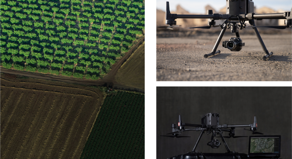
Why the Zenmuse P1 is a must-have?
Captures High-Resolution Data
Zenmuse P1’s 45-megapixel full-frame sensor gathers data onto small pixels measuring about 4.4micrometre. The full-frame sensor produces high-resolution images with low noise and high sensitivity. The P1 permits users to scale up images without losing the image quality because it can capture clear images at higher altitudes. This capability makes the camera perfect for aerial surveying and mapping operations.
High Speed & Greater Efficiency
The first thing you will notice when the Zenmuse P1 is at work is its speed. It captures images at staggeringly fast speed. To be exact, it captures a photo every 0.7 seconds. Once the image is taken, they get stored onto the SD card all within a second. This high speed allows users to capture high-resolution images in a short flight. Users can also cover more ground in a single battery and save more time by reducing the number of flights required. The Zenmuse P1 can cover up to 3km2 at a GSD of 3cm under a single flight, with a 75% front overlap rate and a 55% side overlap rate.
Multiple Lenses for Maximum Efficiency
The Zenmuse P1 one comes with three interchangeable fixed-focus lenses on a 3-axis stabilized gimbal. The lenses contain different angles of view, including 24mm, 35 mm, and 50 mm. All the lenses have a global mechanical shutter with a shutter speed of 1/2000 seconds to prevent the dreaded “Jello Effect" and motion blur. The high shutter speed also helps maintain the image crisp even from a great distance or at high speed.
The three lenses also allow you to determine the size of the area you wish to view during your mission. For large-scale mapping operation, you can use lenses with a wide-angle of view. For nearer, detailed images, you can use narrow focus lenses.
Customizable Mission Modes
Every unique application of the P1 payload receives support from its mission modes. That includes the 2D orthomosaic, 3D oblique, detailed modelling, and real-time mapping mission. DJI has customized every mission to boost the output of the data taken while increasing the efficiency of the mission.
The Zenmuse P1 is a robust tool ideal for every surveyor and mapper. High-resolution image and inflight data get combined, allowing the pilot to receive reliable maps and models. The combination of Zenmuse P1 and Matrice 300 RTK sets new standards for increased efficiency and accuracy in aerial surveying.
Accuracy Without Ground Control Points
The P1 achieves high accuracy without relying on Ground Control Points (GCPs). Even without GCPs, the P1 can reach 3cm horizontally and 5cm vertically when using a mapping mission at a GSD of 3 cm, with a 75% front overlap rate and a 55% side overlap rate. This minimizes the time-consuming and dangerous task of laying GCPs across the site of the project.
3-axis Stabilized Gimbal with Smart Oblique Capture
Thanks to the 3-axis gimbal, the P1 has a smart oblique capture feature for oblique photography to deliver highly accurate 3D and detailed models. The smart oblique capture improves efficiency by mimicking a multi-sensor oblique camera and capturing images crucial to reconstructing the edge of the mapping areas.
TimeSync 2.0
Users can easily synchronize data and positioning to the microsecond, thanks to DJI’s TimeSync 2.0 and the P1’s super-fast shutter. Timesync 2.0 aligns the camera, gimbal, RTK module, and flight controller at the microsecond level. The software also combines with the global mechanical shutter to capture accurate centimetre-level data merged with real-time position and orientation compensation technology. The ability of the camera system to link position with images means you can collect highly accurate data for 3D modelling.
Who Will Benefit from Zenmuse P1?
The Zenmuse P1 offers a new competitive advantage for photogrammetry specialists. It will allow them to work faster and safer, all thanks to its impressive features. With this camera system, surveyors can now carry out complex geological missions around vertical slopes and mountain ranges. They can capture oblique 3D modelling data with centimetre-level accuracy.
Finally, they can take advantage of P1’s efficiency for their projects by maximizing their return on investment and time. The camera system will come in handy in collecting data in various industries, including construction, mining, agriculture, energy, forestry and more.
Final Thoughts
The Zenmuse P1 has opened new levels of efficiency for aerial surveying and mapping. Thanks to the high level of accuracy of the data collected by this camera, surveyors can access better quality data in less time.
If you are in the market for a reliable drone and an advanced aerial camera for surveying or mapping, get in touch with Dronehub today!
Related Stories
Looking for something else?
Ready for more?
Get updates on industry innovations and the latest free assets for
By submitting your information, you are agreeing to receive news, surveys, and special offers from Dronehub Ghana Limited. Terms and Conditions, Privacy Policy
Your preferred drone products and solutions provider in Africa
H/No. 60 Co-Operative Building, Kwame Nkrumah Avenue, Adabraka, Greater Accra, Ghana GA-075-8188
© 2024 Dronehub Ghana Limited All rights reserved.